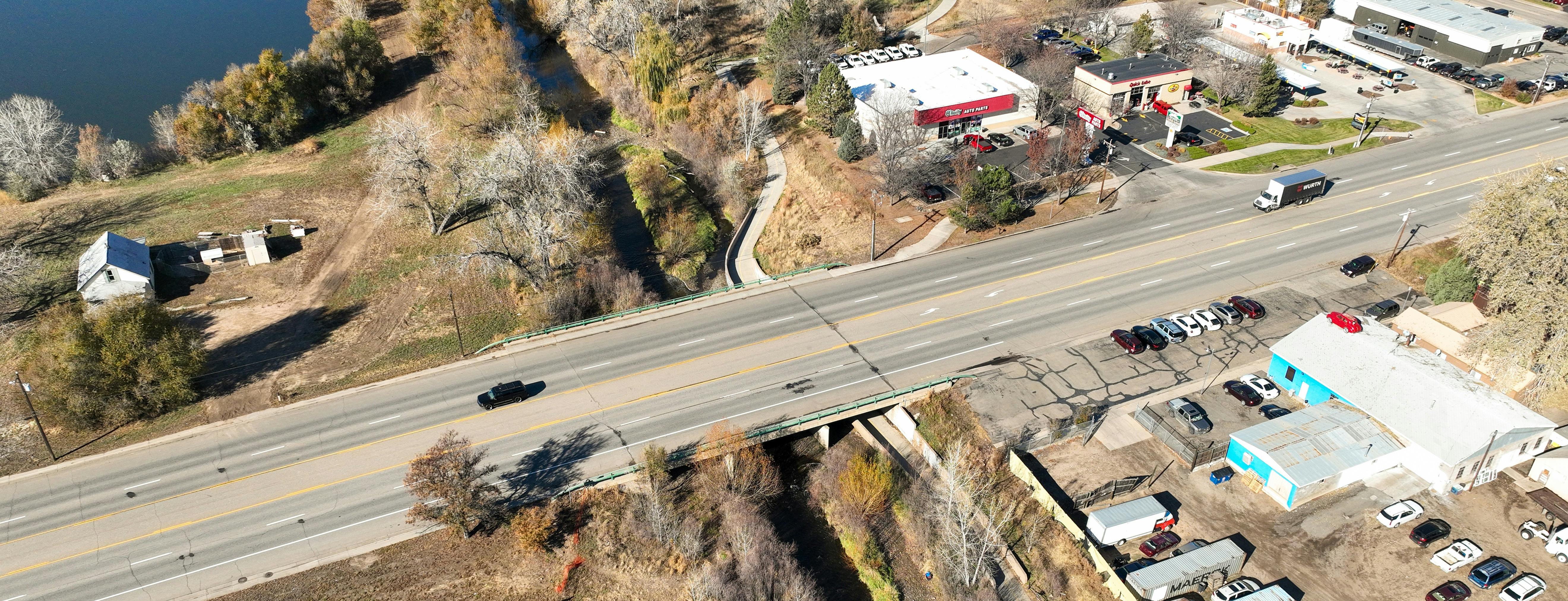
Highway 287 Flood Mitigation Project

Share Highway 287 Flood Mitigation Project on Facebook Share Highway 287 Flood Mitigation Project on Twitter Share Highway 287 Flood Mitigation Project on Linkedin Email Highway 287 Flood Mitigation Project link

History

The Big Thompson River has sustained 13 damaging floods – the most recent occurring in September 2013 resulting in significant damage to public infrastructure and private properties in the Loveland area. Of particular concern was the area of the Big Thompson near U.S. Highway 287 (Lincoln Avenue) where there is the vital north-south highway connection to the City of Loveland, the Burlington Northern-Santa Fe Railroad tracks, two large community parks, the Loveland Fire Rescue Authority’s training facility and a dense cluster of buildings and businesses.

Excluding the cost for emergency response, the 2013 flood caused $9.9 million in damage to public infrastructure in this area. That’s over $18 million in today’s dollars. The Highway 287 bridge nearly failed from scour undermining the piers and north abutment, and the highway was closed for more than two weeks as the river overtopped the roadway. Many businesses were closed for months due to significant flood damage.

The need for more resiliency in this area following the 2013 flood led to the creation of the Big Thompson River Corridor Master Plan which was adopted by City Council in June 2019. This plan identifies numerous projects and river maintenance activities to implement along the nine-mile stretch of the river through the Loveland area. The Highway 287 Flood Mitigation project is one of the highest-priority capital projects identified.

Project Description

The Highway 287 Flood Mitigation project is a joint effort between the City of Loveland, the Colorado Department of Homeland Security and Emergency Management (DHSEM) the Federal Emergency Management Agency (FEMA) and the Colorado Department of Transportation (CDOT) to design flood mitigation measures for the Big Thompson River at Highway 287. This project will focus on the Highway 287 bridge, but the entire project area extends from Railroad Avenue on the west to about Saint Louis Avenue on the east. Along Highway 287, the project area extends about 1,000 feet to the north and south of the river.

The project has three main components: bridge replacement and retrofitting, stream restoration and floodplain improvement. A primary goal is to increase community resiliency by removing as many properties as feasible from the 100-year floodplain and reducing flood risk to those structures that remain in the floodplain.

Project Scope

This project includes designing a new Highway 287 bridge structure over the Big Thompson River that’s about four feet higher and includes four through lanes, a center turn lane, bike lanes and a sidewalk. Other project elements include:

  • Addressing access points throughout the project corridor to accommodate raising the bridge and highway about four feet to help prevent the river from overtopping the roadway.

  • Creating a natural open space corridor by connecting the existing public natural areas and parks just upstream and downstream of the bridge.

  • Reducing flood risk by increasing floodplain capacity adjacent to the river channel and using nature-based solutions (things such as planted vegetation or boulders)

  • Improving opportunities for public interaction with the river through better access.

  • Restoring natural areas and improving river health as best as possible.

  • Creating a signature southern entrance into Loveland.

Project Funding

The project design will cost an estimated $2.6 million with about 90% of the costs being covered by a FEMA grant and 10% from the increased stormwater fee residents started paying on their utility bills in September 2022. An estimate of construction costs will be developed when design work is complete.

Stay Informed

To stay informed about this project, subscribe to our email list in the “Stay Informed” section.


Questions and Answers

Have a question about the project? Ask it below and we'll follow-up shortly!

loader image
Didn't receive confirmation?
Seems like you are already registered, please provide the password. Forgot your password? Create a new one now.
  • Share With a bridge 4' higher, I see the water going around to the south and north anyway. Meanwhile I see Highway 34 flooded with rush hour traffic morning and evenings. We have Wilson, Taft, 287 four laned on the west, but Boise is four laned only to the Farmer's Canal. Why not spend the money to stop the flood of rush hour traffic. Build a four lane bridge on the Farmer's Canal and a bridge south over the Thompson River to open up a north/south four lane road on the east side of town to Highway 402. Then aggressively work with the county to four lane Highway 402 from 287 to I25, because at present there are no plans to widen Highway 402 for at least the next 20 years. Let's get serious about these projects for the resident's best interest. The city put in the existing 287 bridge not all that long ago; why didn't they think of raising it then? Loveland residents would benefit from water mitigation if the moneys were put into Boise and 402, rather than 287 and a scenic view as one comes into Loveland down Derby Hill. on Facebook Share With a bridge 4' higher, I see the water going around to the south and north anyway. Meanwhile I see Highway 34 flooded with rush hour traffic morning and evenings. We have Wilson, Taft, 287 four laned on the west, but Boise is four laned only to the Farmer's Canal. Why not spend the money to stop the flood of rush hour traffic. Build a four lane bridge on the Farmer's Canal and a bridge south over the Thompson River to open up a north/south four lane road on the east side of town to Highway 402. Then aggressively work with the county to four lane Highway 402 from 287 to I25, because at present there are no plans to widen Highway 402 for at least the next 20 years. Let's get serious about these projects for the resident's best interest. The city put in the existing 287 bridge not all that long ago; why didn't they think of raising it then? Loveland residents would benefit from water mitigation if the moneys were put into Boise and 402, rather than 287 and a scenic view as one comes into Loveland down Derby Hill. on Twitter Share With a bridge 4' higher, I see the water going around to the south and north anyway. Meanwhile I see Highway 34 flooded with rush hour traffic morning and evenings. We have Wilson, Taft, 287 four laned on the west, but Boise is four laned only to the Farmer's Canal. Why not spend the money to stop the flood of rush hour traffic. Build a four lane bridge on the Farmer's Canal and a bridge south over the Thompson River to open up a north/south four lane road on the east side of town to Highway 402. Then aggressively work with the county to four lane Highway 402 from 287 to I25, because at present there are no plans to widen Highway 402 for at least the next 20 years. Let's get serious about these projects for the resident's best interest. The city put in the existing 287 bridge not all that long ago; why didn't they think of raising it then? Loveland residents would benefit from water mitigation if the moneys were put into Boise and 402, rather than 287 and a scenic view as one comes into Loveland down Derby Hill. on Linkedin Email With a bridge 4' higher, I see the water going around to the south and north anyway. Meanwhile I see Highway 34 flooded with rush hour traffic morning and evenings. We have Wilson, Taft, 287 four laned on the west, but Boise is four laned only to the Farmer's Canal. Why not spend the money to stop the flood of rush hour traffic. Build a four lane bridge on the Farmer's Canal and a bridge south over the Thompson River to open up a north/south four lane road on the east side of town to Highway 402. Then aggressively work with the county to four lane Highway 402 from 287 to I25, because at present there are no plans to widen Highway 402 for at least the next 20 years. Let's get serious about these projects for the resident's best interest. The city put in the existing 287 bridge not all that long ago; why didn't they think of raising it then? Loveland residents would benefit from water mitigation if the moneys were put into Boise and 402, rather than 287 and a scenic view as one comes into Loveland down Derby Hill. link

    With a bridge 4' higher, I see the water going around to the south and north anyway. Meanwhile I see Highway 34 flooded with rush hour traffic morning and evenings. We have Wilson, Taft, 287 four laned on the west, but Boise is four laned only to the Farmer's Canal. Why not spend the money to stop the flood of rush hour traffic. Build a four lane bridge on the Farmer's Canal and a bridge south over the Thompson River to open up a north/south four lane road on the east side of town to Highway 402. Then aggressively work with the county to four lane Highway 402 from 287 to I25, because at present there are no plans to widen Highway 402 for at least the next 20 years. Let's get serious about these projects for the resident's best interest. The city put in the existing 287 bridge not all that long ago; why didn't they think of raising it then? Loveland residents would benefit from water mitigation if the moneys were put into Boise and 402, rather than 287 and a scenic view as one comes into Loveland down Derby Hill.

    Roy asked 10 months ago

    Hello! Thank you for your comment. The Highway 287 Flood Mitigation Project is a comprehensive river corridor project that ties into the "A Better Big T" Master Plan. The master plan addresses the most critical issues by improving areas of the river along U.S. Highway 287 and determining the impacts of Loveland's floodplains. The Highway 287 Flood Mitigation Project will focus on on the Highway 287 bridge, but the entire project area extends from Railroad Avenue on the west to about Saint Louis Avenue on the east. Along Highway 287, the project area extends about 1,000 feet to the north and south of the river.

    This project has three main components: bridge replacement and retrofitting, stream restoration and floodplain improvement. A primary goal is to increase community resiliency by reducing flood risk to those structures that remain in the floodplain.

    You bring up some great points about other important transportation connections and future projects. In October 2023, Loveland's City Council adopted Connect Loveland, which addresses our transportation master plan for Loveland through 2040. The 402 Corridor will be widened per the transportation plan as the area develops.   

    We have shared your comment to our Transportation and Stormwater Engineering Divisions. If you have additional questions, you can contact us at 970-962-2524 or PublicWorksInfo@cityofloveland.org. Thank you!

  • Share Will you be annexing the St Louis Bridge? on Facebook Share Will you be annexing the St Louis Bridge? on Twitter Share Will you be annexing the St Louis Bridge? on Linkedin Email Will you be annexing the St Louis Bridge? link

    Will you be annexing the St Louis Bridge?

    Caryn asked 9 months ago

    Hello! Thank you for your question. The St Louis Bridge is in the growth management area for the City of Loveland. As we look at future infrastructure and the City's transportation master plan, Connect Loveland, St Louis Bridge could be potentially annexed in the future. If you have questions specifically about our growth management plan, you can contact our Transportation or Stormwater Divisions at 970-962-2524 or PublicWorksInfo@cityofloveland.org. Thank you! 

  • Share Will there be an underpass for a bike lane when the new bridge is built ? on Facebook Share Will there be an underpass for a bike lane when the new bridge is built ? on Twitter Share Will there be an underpass for a bike lane when the new bridge is built ? on Linkedin Email Will there be an underpass for a bike lane when the new bridge is built ? link

    Will there be an underpass for a bike lane when the new bridge is built ?

    jimboers asked 10 months ago

    Hello, thank you for your question! Yes, the plan is to have a pedestrian underpass for the recreation trail under the new bridge, like the existing underpass for bikers and walkers along the Big Thompson River. We are working collaboratively with the Parks and Recreation Department. If you would like to discuss this more specifically with the Parks and Recreation engineers for this project, you can contact them at 970-962-2727 or parks@cityofloveland.org. Thank you! 

Page last updated: 25 Jul 2024, 12:58 PM